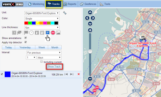
A track is the path traveled by a vehicle during a specified period. The "Tracks" module can be used to construct historic tracks of the vehicle, which can be used to analyze the movement of the vehicle and investigate historic information regarding the vehicle.

Select the vehicle from the drop down menu named "Unit". Select the interval for which you wish to plot the track. Standard intervals like "Today", "Yesterday", "Week" and "Month" can be selected by clicking the appropriate buttons. More specific intervals can be selected from the drop down menu named "Interval".
After selecting a specific interval, click "Show Track" to display the track on the map.
The details of the map including the length of the track (which is the distance traveled by the vehicle during the selected interval) is displayed below the "Show Track" button.
The color of the track can be pre-selected from the available colors. This is useful to differentiate when multiple tracks are plotted.
Specialized markers are available like  for Parkings and
  for Stops, which can be pre-selected from the list of markers presented. These will be positioned along the tracks wherever the vehicle was parked or stopped, as the case maybe.
Fuel theft and fuel filling markers are also available which can show the location where a theft or a filling has taken place, respectively.